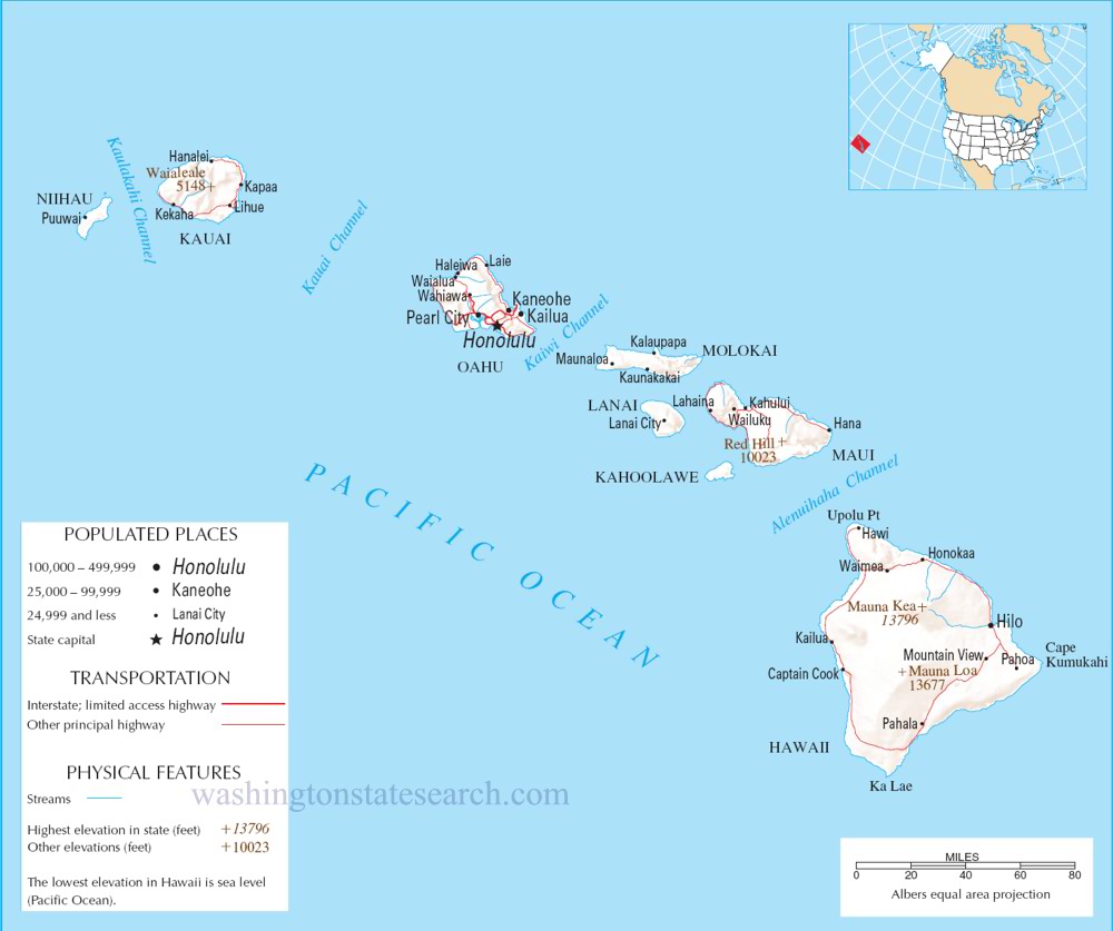
Hawaii State Map
Home Page > United States Map > Hawaii State Map
About Hawaii State
Hawaii is the 50th and most recent state to have joined the United States, officially becoming a state on August 21, 1959. It is an archipelago located in the central Pacific Ocean, about 2,400 miles (3,862.42 km) southwest of California. The state is composed of eight main islands, although there are also many smaller islands and islets.
Here are the eight main islands of Hawaii, listed from northwest to southeast:
Niihau
The westernmost and privately owned island, known for its seclusion and limited access.
Kauai
Known as the "Garden Isle" for its lush landscapes and diverse ecosystems.
Oahu
The most populous island, home to the state capital, Honolulu, and famous landmarks such as Waikiki Beach and Pearl Harbor.
Molokai
A more rural and less developed island, known for its natural beauty and the Kalaupapa National Historical Park.
Lanai
Once known for its pineapple plantations, Lanai is now a private island with luxury resorts.
Maui
Known for its stunning beaches, volcanic landscapes, and the scenic "Road to Hana."
Kahoolawe
Historically used for target practice by the U.S. military, Kahoolawe is currently uninhabited and undergoing ecological restoration.
Hawaii (the Big Island)
The largest and youngest island, known for its active volcanoes, diverse climates, and the town of Hilo.
Hawaii has a unique cultural and historical background. It was originally settled by Polynesians who arrived in canoes, and their descendants developed a distinct Hawaiian culture. Captain James Cook is credited with the first recorded European contact with the islands in 1778.
The overthrow of the Hawaiian Kingdom in 1893 and subsequent annexation by the United States in 1898 are pivotal events in Hawaii's history. The state is now a diverse blend of cultures and is known for its multicultural population.
The economy of Hawaii is heavily dependent on tourism, agriculture, and military defense. The state's tropical climate, stunning landscapes, and vibrant culture make it a popular destination for visitors from around the world. Additionally, the U.S. Pacific Command, headquartered at Pearl Harbor, plays a crucial role in the region's military defense.
A large detailed map of Hawaii State
This is a large detailed map of Hawaii State.
View our Hawaii State county map

from the National Atlas of the United States
United States Department of the Interior
Hawaii State Map
The electronic map of Hawaii State that is located below is provided by Google Maps. You can "grab" the Hawaii State map and move it around to re-centre the map. You can change between standard map view and satellite map view by clicking the small square on the bottom left hand corner of the map. Satellite map view utilizes orbiting satellite or aerial high resolution photography to display images of the map location to street level detail (really quite amazing). Standard map view shows a traditional street map (also known as a road map). You can use the zoom buttons on the bottom right hand side of the map to zoom in or out to street level detail. We have maps for most towns and cities in the US, so click on the United States Maps link to see more American online maps.
Music


