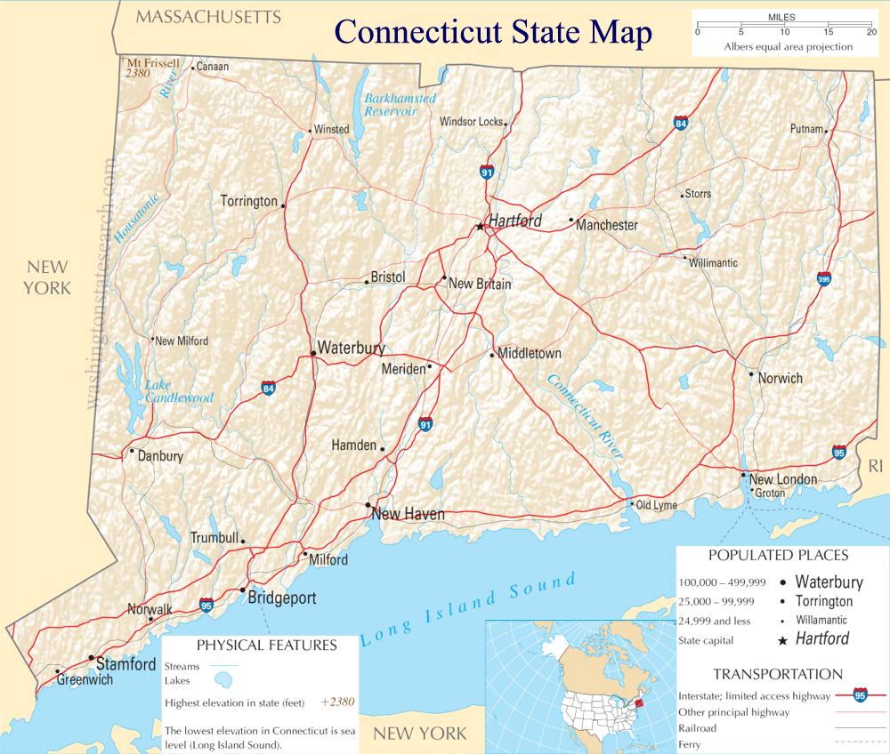
Connecticut State Map
Home Page > United States Map > Connecticut State Map
About Connecticut State
Connecticut is a state located in the New England region of the northeastern United States. Here are some key points about Connecticut:
Capital and Major Cities
The capital of Connecticut is Hartford, which is located in the central part of the state. Other major cities include Bridgeport, New Haven, Stamford, and Waterbury.
Geography
Connecticut is a relatively small state but is known for its diverse geography. It has coastal areas along Long Island Sound, rolling hills, and forested landscapes.
Economy
Connecticut has a diverse and prosperous economy. It is known for its financial and insurance industries, with cities like Hartford being major centers for these sectors. The state is also involved in manufacturing, particularly in aerospace and defense industries. Additionally, healthcare and education are significant contributors to the economy.
Education
Connecticut is home to several prestigious universities, including Yale University in New Haven, one of the Ivy League institutions. Other notable institutions include the University of Connecticut (UConn) and Wesleyan University.
History
Connecticut has a rich colonial history and played a key role in the American Revolutionary War. The Fundamental Orders of Connecticut, adopted in 1639, is considered one of the earliest written constitutions in the world. The state has historical sites such as Mark Twain's house in Hartford and the Mystic Seaport, which preserves a maritime way of life.
Culture
Connecticut has a vibrant cultural scene with numerous museums, theaters, and art galleries. The Yale Center for British Art and the Wadsworth Atheneum Museum of Art are notable cultural institutions. The state also hosts various festivals and events throughout the year, celebrating its rich history and diverse communities.
Quality of Life
Connecticut is often associated with a high quality of life. It has a mix of urban and suburban areas, and residents benefit from access to cultural amenities, good schools, and a relatively low crime rate.
Transportation
The state has a well-developed transportation infrastructure. It is well-connected by highways and has an extensive commuter rail network linking it to neighboring states and New York City.
Natural Beauty
Despite its small size, Connecticut boasts natural beauty, especially along its coastline and in areas like Litchfield Hills. Outdoor activities such as hiking and boating are popular.
Demographics
Connecticut is one of the wealthier states in the U.S., and it has a diverse population. The state is known for its suburban communities and is part of the broader metropolitan area that includes New York City.
Connecticut, with its mix of history, economic prosperity, cultural richness, and natural beauty, offers residents a well-rounded living experience.
A large detailed map of Connecticut State
This is a large detailed map of Connecticut State.
View our Connecticut State county map

from the National Atlas of the United States
United States Department of the Interior
Connecticut State Map
The electronic map of Connecticut State that is located below is provided by Google Maps. You can "grab" the Connecticut State map and move it around to re-centre the map. You can change between standard map view and satellite map view by clicking the small square on the bottom left hand corner of the map. Satellite map view utilizes orbiting satellite or aerial high resolution photography to display images of the map location to street level detail (really quite amazing). Standard map view shows a traditional street map (also known as a road map). You can use the zoom buttons on the bottom right hand side of the map to zoom in or out to street level detail. We have maps for most towns and cities in the US, so click on the United States Maps link to see more American online maps.
Music


